ETH Zurich students build underwater drone to measure ice thickness safely
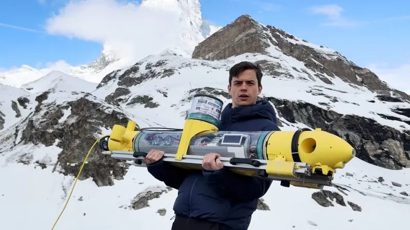
Every winter, frozen lakes host everything from car races to ice skating events, but venturing onto ice always carries risk. The key safety measure is knowing whether the ice is thick enough to bear the weight above it. Traditionally, this is done by drilling holes and measuring ice depth by hand at several points — a dangerous and imprecise method that yields only a rough picture of the actual conditions. To address this, a team of students at ETH Zurich has developed an underwater drone that measures ice thickness automatically.
The measurement concept is straightforward in theory. When a sonar pulse is emitted, part of the energy bounces off the underside of the ice sheet, while another portion passes through it and produces a second return. By measuring the time difference between these two echoes, ice thickness can be calculated with high precision. Mounting the sonar on a submersible equipped with a positioning system should, in principle, produce a full thickness map. In practice, however, the students found that applying the theory was far more challenging.
The submersible is slightly positively buoyant. It carries two concrete ballasts to adjust its center of gravity and six propulsion motors, giving it six degrees of freedom. An NVIDIA Jetson module powers autonomous operations, and the craft is packed with sensors. Navigation relies on a combination of systems, primarily GPS and SBL (super short baseline). The GPS antenna sits inside a radome on top of the submersible, ensuring a strong enough signal for reliable positioning even underwater.
The drone is still a prototype, but its creators believe it could replace manual ice checks with a safer, more accurate alternative. Such a tool would be especially valuable in regions where winter activities on frozen lakes are common, helping organizers assess risk without endangering workers.